It’s been three years since my big hike on the GR10 and I am craving another long hike in the mountains. I’ve done some shorter long distance hikes since, like the Cape Wrath Trail and the Harzer Hexen-Stieg, but nothing approaching a 1000km hike in high mountains. When searching for a trail to be my summer 2026 challenge I had some requirements:
- No flying required (so staying in Europe)
- It needs to be in proper mountains (so no UK trails)
- I want it to be warm and sunny (so no Scandinavian trails)
- I want it to have a real finish/end (so ideally ending at a coast)
I had considered several E-routes for a section hike, but these typically do not stay in the mountains only. Then I came across the Grand Italian Trail, or the Sentiero Italia, a 7,850km trail crossing all the mountainous regions of Italy. While I would absolutely love to try and hike this trail in one trip, reality is that I needed to choose a section to hike.
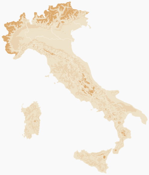
So, with the idea of wanting to hike 1000km and feeling like there would be a real finish to my section hike, I decided to hike in the Italian Alps, from Cannobio on the shore of Lago Maggiore in Piedmont to Loano on the Mediterranean Coast. A total of 1,053km in length, climbing 66,560m, and the highest point 3314m (Testa Grigia summit).
There is no printed guidebook for this hike but this website (https://www.vasentiero.org/en/grand-italian-trail) provides a lot of information and GPX files for every section of the Grand Italian Trail. Thus, after having downloaded all the files that make up the section I chose to hike, I created a multi-day hike in Komoot, splitting the 1053km into 45 stages (see the route collection here).
I am not sure I can complete this section in 45 days and not all sections finish in a logical place, but these sections are only a guideline. Without a guidebook relating infrastructure on the trail, the most important thing to figure out is where I can get groceries. Using Komoot and Google Maps, I went over all the 45 sections in detail to locate all the grocery shops I would encounter and created an Excel file to take not of them and calculate how many days of food I would need from a particular shop.
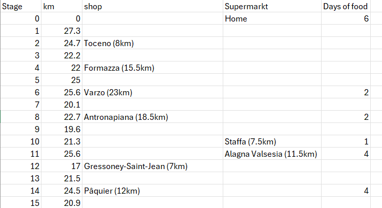
Some shops in small villages seem limited in stock and not open very often or long and thus I noted them on my spreadsheet but did not count them in as a resupply point. The reason being that I would be in trouble if there would be nothing available there after all and lucky to get some fresh food if the shop does turn out to be open.
Water is also very important but it will be easier to navigate this while on the trail as water points on Komoot, for example, do not always exist or work. Therefore, I did not bother trying to locate all the water points on my route.
With the trail decided and my annual leave arranged for summer 2026, I booked a seat on the Eurostar to Paris and my onward train journeys. It will take me a full travel day to reach Lake Maggiore, and the next day I will take the first ferry to take me across the lake to Cannobio to start this new big adventure!

Heel leuk! Ik kijk met plezier je filmpjes. Succes en plezier gewenst!
LikeLiked by 1 person